Aerial photography
Monitoring Polar Changes: Scientists Deploy Many Tools to Measure Sea Ice Thickness
December 29, 2014
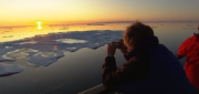
The extent of the polar ice caps is shrinking. This simple fact has been common knowledge since the late 1970s thanks to the added...
December 29, 2014
The extent of the polar ice caps is shrinking. This simple fact has been common knowledge since the late 1970s thanks to the added...
Imagery Options for Esri Users. Esri’s ArcGIS Marketplace
December 29, 2014
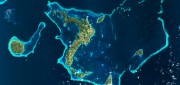
IS users increasingly expect content to come with their platform, rather than be an add-on. To help meet this expectation,...
December 29, 2014
IS users increasingly expect content to come with their platform, rather than be an add-on. To help meet this expectation,...
Tethered Aerostats Provide Another Option in the Sky
October 31, 2014
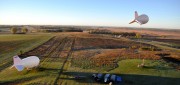
Geospatial professionals are able to choose from an increasingly wide array of platforms on which to deploy ever more accurate...
October 31, 2014
Geospatial professionals are able to choose from an increasingly wide array of platforms on which to deploy ever more accurate...

Google Earth Outreach Continues Collaborations for Earth Modeling and Monitoring
June 10, 2014
Google Earth is all about putting things in geographic context, aiding literacy and helping users in discovery. This capacity...
June 10, 2014
Google Earth is all about putting things in geographic context, aiding literacy and helping users in discovery. This capacity...

UAS for Agriculture, Ready for Take-off
February 26, 2014
Unmanned aerial systems (UAS) have recently become ubiquitous in the mass media and in trade publications, due to a variety...
February 26, 2014
Unmanned aerial systems (UAS) have recently become ubiquitous in the mass media and in trade publications, due to a variety...
Lidar Innovations: Software Catching Up, Alternative Technologies Emerge
February 24, 2014
Throughout its history, lidar has been one of the very few technologies in which the exponential growth in the hardware’s...
February 24, 2014
Throughout its history, lidar has been one of the very few technologies in which the exponential growth in the hardware’s...

Can Satellites in the Sky Help Prevent Atrocities on Earth?
November 25, 2013
Currently, about a dozen government and commercial Earth-imaging satellites circle the Earth daily. They take thousands of pictures...
November 25, 2013
Currently, about a dozen government and commercial Earth-imaging satellites circle the Earth daily. They take thousands of pictures...
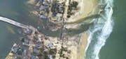
Mapping the Damage from Superstorm Sandy
July 22, 2013
When it hit the United States as a post-tropical cyclone, Sandy had a diameter of 1,100 miles and had been the largest Atlantic...
July 22, 2013
When it hit the United States as a post-tropical cyclone, Sandy had a diameter of 1,100 miles and had been the largest Atlantic...
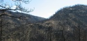
Sensing the Forest for Fuel, Fire, and Recovery
May 6, 2013
Every year, several hundred million hectares of forest, grasslands, and other types of vegetation burn throughout the world,...
May 6, 2013
Every year, several hundred million hectares of forest, grasslands, and other types of vegetation burn throughout the world,...

Mark Romano: Earth Eye Makes Inroads in Sensor Fusion
November 5, 2012
Earth Eye is a relatively new company that has been focused on LiDAR data capture, and the fusion of LiDAR with other sensor...
November 5, 2012
Earth Eye is a relatively new company that has been focused on LiDAR data capture, and the fusion of LiDAR with other sensor...