Geospatial topics
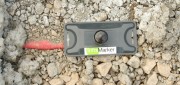
RFID Crazy: RFID-enabled infrastructure marking could become a cornerstone for a connected infrastructure management world.
March 19, 2019
Imagine if all public works engineers and utility company crew chiefs were equipped with a mobile device that could easily...
March 19, 2019
Imagine if all public works engineers and utility company crew chiefs were equipped with a mobile device that could easily...

High Precision GPS to Help Automated Bulk Volume Estimation ? Here’s why…
March 5, 2019
The Challenge For the past 150 years, feedlot monitoring has been the responsibility of a select few employees, who visually...
March 5, 2019
The Challenge For the past 150 years, feedlot monitoring has been the responsibility of a select few employees, who visually...

How GNSS Receivers Empower Smart Cities
March 5, 2019
By 2050, more than 60 percent of the world's population is expected to live in urban areas. Cities are facing this rapid...
March 5, 2019
By 2050, more than 60 percent of the world's population is expected to live in urban areas. Cities are facing this rapid...

Aerial Self-sufficiency
March 5, 2019
A large risk-assessment and data-analytics company created its own internal system to collect imagery, write software, and develop...
March 5, 2019
A large risk-assessment and data-analytics company created its own internal system to collect imagery, write software, and develop...
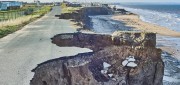
Predicting Crumbling Cliffs
March 5, 2019
Cliff Erosion: a Global Issue In 2012, nine homes in Happisburgh, an historic village on England’s Norfolk coast,...
March 5, 2019
Cliff Erosion: a Global Issue In 2012, nine homes in Happisburgh, an historic village on England’s Norfolk coast,...
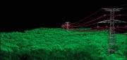
Standalone UAV Lidar
March 5, 2019
A surveying company developed a self-contained UAV lidar system so teams could gather data without a lidar specialist. Some...
March 5, 2019
A surveying company developed a self-contained UAV lidar system so teams could gather data without a lidar specialist. Some...
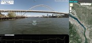
Street Views of the Water
November 6, 2018
Mapping rivers above and below the surface creates great opportunity for engineers and stewards. The way maps are produced...
November 6, 2018
Mapping rivers above and below the surface creates great opportunity for engineers and stewards. The way maps are produced...
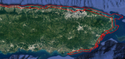
After the Storm
November 6, 2018
Post-hurricane coastal mapping is a complex process made easier with airborne bathymetry. Lately, large storms such as hurricanes,...
November 6, 2018
Post-hurricane coastal mapping is a complex process made easier with airborne bathymetry. Lately, large storms such as hurricanes,...

mESRIsoft
November 6, 2018
More than partners, Esri and Microsoft collaborate and combine platforms to benefit their users and the public. From their...
November 6, 2018
More than partners, Esri and Microsoft collaborate and combine platforms to benefit their users and the public. From their...

Not Everything Requires High Accuracies
November 6, 2018
How feature inspection, assessment, and reporting are now available to non-experts (and experts alike). In the early 2000s,...
November 6, 2018
How feature inspection, assessment, and reporting are now available to non-experts (and experts alike). In the early 2000s,...