Informed Infrastructure

Wetlands Worth their Weight
March 2, 2016
"Wetland" is a generic term covering a wide variety of habitats that are wet for at least some period of time each year,...
March 2, 2016
"Wetland" is a generic term covering a wide variety of habitats that are wet for at least some period of time each year,...
Oregon Preparing for Export: Assessing the Seismic Challenges of a Liquified Natural Gas Plant
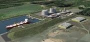
December 3, 2015
In the international port of Coos Bay, Ore., construction will begin in late 2016 on a liquefied natural gas (LNG) export...
December 3, 2015
In the international port of Coos Bay, Ore., construction will begin in late 2016 on a liquefied natural gas (LNG) export...

Sewer Heat Recovery Provides Low-Cost Recycled Energy
October 24, 2012
In every urban area, heat that humans have generated to shower, wash clothes, cook, and so on flows underground — in the sewers,...
October 24, 2012
In every urban area, heat that humans have generated to shower, wash clothes, cook, and so on flows underground — in the sewers,...