Bathymetry
Street Views of the Water
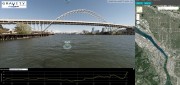
November 6, 2018
Mapping rivers above and below the surface creates great opportunity for engineers and stewards. The way maps are produced...
November 6, 2018
Mapping rivers above and below the surface creates great opportunity for engineers and stewards. The way maps are produced...
After the Storm
November 6, 2018
Post-hurricane coastal mapping is a complex process made easier with airborne bathymetry. Lately, large storms such as hurricanes,...
November 6, 2018
Post-hurricane coastal mapping is a complex process made easier with airborne bathymetry. Lately, large storms such as hurricanes,...
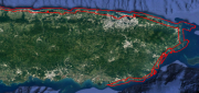
Mapping the Scottish Seabed
February 21, 2017
On land, surveyors face challenges due to rough terrain, human activity, weather, and more. Usually, however, the ground...
February 21, 2017
On land, surveyors face challenges due to rough terrain, human activity, weather, and more. Usually, however, the ground...

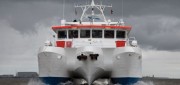
Robots of the Deep
October 10, 2016
We have mapped the surface of the Moon at a resolution of 328 feet. We have mapped the surface of Mars. Yet, here on Earth,...
October 10, 2016
We have mapped the surface of the Moon at a resolution of 328 feet. We have mapped the surface of Mars. Yet, here on Earth,...
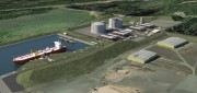
Oregon Preparing for Export: Assessing the Seismic Challenges of a Liquified Natural Gas Plant
December 3, 2015
In the international port of Coos Bay, Ore., construction will begin in late 2016 on a liquefied natural gas (LNG) export...
December 3, 2015
In the international port of Coos Bay, Ore., construction will begin in late 2016 on a liquefied natural gas (LNG) export...
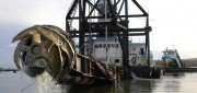
Survey. Dredge. Repeat. Keeping the Columbia River Navigable
December 29, 2014
As the skipper of Galileo 3, a 30-foot sailboat on the Columbia River, I tell my crew that I am comfortable with 15 feet...
December 29, 2014
As the skipper of Galileo 3, a 30-foot sailboat on the Columbia River, I tell my crew that I am comfortable with 15 feet...

From Shore to Floor
October 16, 2014
More than 90% of the world’s trade is carried by sea, according to the International Maritime Organization. Therefore,...
October 16, 2014
More than 90% of the world’s trade is carried by sea, according to the International Maritime Organization. Therefore,...