Energy

Robots of the Deep
October 10, 2016
We have mapped the surface of the Moon at a resolution of 328 feet. We have mapped the surface of Mars. Yet, here on Earth,...
October 10, 2016
We have mapped the surface of the Moon at a resolution of 328 feet. We have mapped the surface of Mars. Yet, here on Earth,...
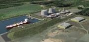
Oregon Preparing for Export: Assessing the Seismic Challenges of a Liquified Natural Gas Plant
December 3, 2015
In the international port of Coos Bay, Ore., construction will begin in late 2016 on a liquefied natural gas (LNG) export...
December 3, 2015
In the international port of Coos Bay, Ore., construction will begin in late 2016 on a liquefied natural gas (LNG) export...

Maximizing the Sun: Solar energy grows in part due to aerial imaging and surveying
April 10, 2015
Solar power is booming in the United States. “Every three weeks,” President Obama said in his 2015 State of the Union...
April 10, 2015
Solar power is booming in the United States. “Every three weeks,” President Obama said in his 2015 State of the Union...

Measuring Distant Winds: Remote Sensing for Siting Wind Turbines
July 8, 2013
Wind's contribution to energy production in the United States continues to grow. In 2011, it represented a third of all new electric...
July 8, 2013
Wind's contribution to energy production in the United States continues to grow. In 2011, it represented a third of all new electric...

Sewer Heat Recovery Provides Low-Cost Recycled Energy
October 24, 2012
In every urban area, heat that humans have generated to shower, wash clothes, cook, and so on flows underground — in the sewers,...
October 24, 2012
In every urban area, heat that humans have generated to shower, wash clothes, cook, and so on flows underground — in the sewers,...