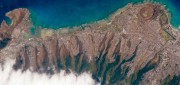
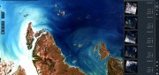
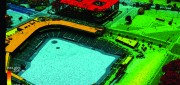
Remote sensing

GNSS Helps Fight Coronavirus While Companies Adapt
October 11, 2020
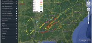
As part of the effort to combat the spread of COVID-19 in the United States, UAV company Draganfly has partnered with Australia’s...
October 11, 2020
As part of the effort to combat the spread of COVID-19 in the United States, UAV company Draganfly has partnered with Australia’s...
Companies Apply Machine Learning for Ag
March 6, 2018
The shift in the Earth observation (EO) market from selling pixels to selling finished intelligence products has sharply...
March 6, 2018
The shift in the Earth observation (EO) market from selling pixels to selling finished intelligence products has sharply...
Geospatial Analytics-as-a-Service & Platforms
February 7, 2018
The field of Earth Observation (EO) has seen two big changes in recent years: first, the massive increase in the number and variety...
February 7, 2018
The field of Earth Observation (EO) has seen two big changes in recent years: first, the massive increase in the number and variety...
FINAL ARTICLE IN THE SERIES on Geospatial Processing & Visualization: Ubisense and Harris Geospatial Solutions
August 4, 2017
The line between vendors of geospatial software and providers of geospatial data is increasingly blurred, as more companies...
August 4, 2017
The line between vendors of geospatial software and providers of geospatial data is increasingly blurred, as more companies...
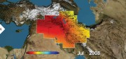
Satellite Missions Improve Water Estimates
April 28, 2017
Fresh water is humanity’s single most critical resource. According to a recent United Nations report, stresses on water...
April 28, 2017
Fresh water is humanity’s single most critical resource. According to a recent United Nations report, stresses on water...
Building “Digital Earth”
February 23, 2017
A new generation of geospatial intelligence helps to answer complex geographic questions Paper maps obsolesce rapidly from...
February 23, 2017
A new generation of geospatial intelligence helps to answer complex geographic questions Paper maps obsolesce rapidly from...
CLIVE: Communicating Risk in 3D
February 21, 2017
Static 3D models of topography and buildings are commonplace in both technical and popular geospatial software. There are still...
February 21, 2017
Static 3D models of topography and buildings are commonplace in both technical and popular geospatial software. There are still...
Surveying a Mountain Highway with UAS
February 21, 2017
In the steep canyons of the Republic of Macedonia, AKTOR ADT, an international construction company based in Athens, Greece,...
February 21, 2017
In the steep canyons of the Republic of Macedonia, AKTOR ADT, an international construction company based in Athens, Greece,...

From Selling Pixels to Selling Answers
February 21, 2017
This series of articles began in our Fall 2015 issue by focusing on the impact on vendors and users of geospatial technologies...
February 21, 2017
This series of articles began in our Fall 2015 issue by focusing on the impact on vendors and users of geospatial technologies...
Freeing Slaves from the High Seas
February 21, 2017
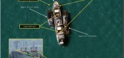
In May 2015, former slave fisherman Myint Naing, 40, was reunited with his family after 22 years. He was among hundreds of former...
February 21, 2017
In May 2015, former slave fisherman Myint Naing, 40, was reunited with his family after 22 years. He was among hundreds of former...