Earth Imaging Journal
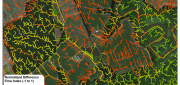
LiDAR, GIS and the Chesapeake Conservancy: Precision Conservation
June 2, 2016
Building on the practice of precision agriculture and exploiting recent computer advances, the Chesapeake Conservancy (CC)...
June 2, 2016
Building on the practice of precision agriculture and exploiting recent computer advances, the Chesapeake Conservancy (CC)...
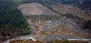
See the Light: LiDAR Data Help Expose Landslide Hazards
October 12, 2015
On March 22, 2014, four miles east of Oso, Wash., a portion of an unstable hill collapsed, sending mud and debris across...
October 12, 2015
On March 22, 2014, four miles east of Oso, Wash., a portion of an unstable hill collapsed, sending mud and debris across...

Moving Forward with UAS Mapping
June 16, 2015
For geospatial professionals, the most exciting aspect of the current explosion in unmanned aircraft systems (UASs) is using...
June 16, 2015
For geospatial professionals, the most exciting aspect of the current explosion in unmanned aircraft systems (UASs) is using...
Sensor Fusion: Deriving Information from Data
April 9, 2015
The current explosion in the variety, capability and sheer number of sensors is generating a flood of data intended to enhance...
April 9, 2015
The current explosion in the variety, capability and sheer number of sensors is generating a flood of data intended to enhance...

Developing the Map of the Future
April 9, 2015
Geospatial technology is changing. Now geographic information system (GIS) software is ingesting, organizing and visualizing...
April 9, 2015
Geospatial technology is changing. Now geographic information system (GIS) software is ingesting, organizing and visualizing...

Monitoring Polar Changes: Scientists Deploy Many Tools to Measure Sea Ice Thickness
December 29, 2014
The extent of the polar ice caps is shrinking. This simple fact has been common knowledge since the late 1970s thanks to the added...
December 29, 2014
The extent of the polar ice caps is shrinking. This simple fact has been common knowledge since the late 1970s thanks to the added...