Mapping and cartography
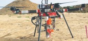
UAV Stakes Out New Ground
September 27, 2019
A flying/staking robot has taken a huge step forward in automation for site layout, including road, rail, utilities, and energy...
September 27, 2019
A flying/staking robot has taken a huge step forward in automation for site layout, including road, rail, utilities, and energy...
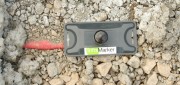
RFID Crazy: RFID-enabled infrastructure marking could become a cornerstone for a connected infrastructure management world.
March 19, 2019
Imagine if all public works engineers and utility company crew chiefs were equipped with a mobile device that could easily...
March 19, 2019
Imagine if all public works engineers and utility company crew chiefs were equipped with a mobile device that could easily...
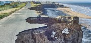
Predicting Crumbling Cliffs
March 5, 2019
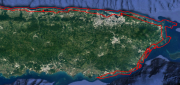
Cliff Erosion: a Global Issue In 2012, nine homes in Happisburgh, an historic village on England’s Norfolk coast,...
March 5, 2019
Cliff Erosion: a Global Issue In 2012, nine homes in Happisburgh, an historic village on England’s Norfolk coast,...
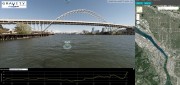
Street Views of the Water
November 6, 2018
Mapping rivers above and below the surface creates great opportunity for engineers and stewards. The way maps are produced...
November 6, 2018
Mapping rivers above and below the surface creates great opportunity for engineers and stewards. The way maps are produced...
After the Storm
November 6, 2018
Post-hurricane coastal mapping is a complex process made easier with airborne bathymetry. Lately, large storms such as hurricanes,...
November 6, 2018
Post-hurricane coastal mapping is a complex process made easier with airborne bathymetry. Lately, large storms such as hurricanes,...

Not Everything Requires High Accuracies
November 6, 2018
How feature inspection, assessment, and reporting are now available to non-experts (and experts alike). In the early 2000s,...
November 6, 2018
How feature inspection, assessment, and reporting are now available to non-experts (and experts alike). In the early 2000s,...

Where the Data Comes From
November 6, 2018
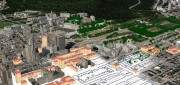
Members of Esri’s Living Atlas unit detail the company’s wide variety of data sources. For nearly 50 years, Esri has been...
November 6, 2018
Members of Esri’s Living Atlas unit detail the company’s wide variety of data sources. For nearly 50 years, Esri has been...
Easing the 3D Workflow
February 19, 2018
For 30 years, an Alaska-based company has been producing digital mapping and photogrammetic software to help automate the complex...
February 19, 2018
For 30 years, an Alaska-based company has been producing digital mapping and photogrammetic software to help automate the complex...

Managing Canada’s Data
February 7, 2018
From mapping utility poles to mapping radio frequency signal leaks, this company collects and manages much of the country’s...
February 7, 2018
From mapping utility poles to mapping radio frequency signal leaks, this company collects and manages much of the country’s...
Recording, Registration, and Cadastres
September 18, 2017
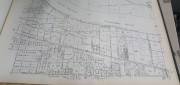
An accurate and up-to-date record of property boundaries is essential for administering property taxes, enforcing environmental...
September 18, 2017
An accurate and up-to-date record of property boundaries is essential for administering property taxes, enforcing environmental...