Professional Surveyor Magazine
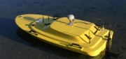
Hydrography by Remote
May 6, 2014
Before they even start taking measurements, surveyors often have to deal with such practical challenges as how to access...
May 6, 2014
Before they even start taking measurements, surveyors often have to deal with such practical challenges as how to access...

Under Thin Ice: Mapping changing glaciers from the inside
February 27, 2014
Mountaineers climb mountains. Cavers explore caves. Surveyors measure and map. In Oregon, a small team of people with all three...
February 27, 2014
Mountaineers climb mountains. Cavers explore caves. Surveyors measure and map. In Oregon, a small team of people with all three...
Surveying Cultural Heritage
December 6, 2013
CyArk, a nonprofit organization dedicated to digitally preserving and sharing the world’s cultural heritage, uses laser...
December 6, 2013
CyArk, a nonprofit organization dedicated to digitally preserving and sharing the world’s cultural heritage, uses laser...
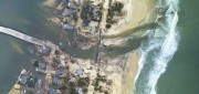
Mapping the Damage from Superstorm Sandy
July 22, 2013
When it hit the United States as a post-tropical cyclone, Sandy had a diameter of 1,100 miles and had been the largest Atlantic...
July 22, 2013
When it hit the United States as a post-tropical cyclone, Sandy had a diameter of 1,100 miles and had been the largest Atlantic...

The Oregon Lidar Consortium
January 4, 2013
In less than six years since it was formed, the Oregon Lidar Consortium (OLC) has collected 16 million acres of high-resolution...
January 4, 2013
In less than six years since it was formed, the Oregon Lidar Consortium (OLC) has collected 16 million acres of high-resolution...