Sensors & Systems

Going Beyond Global Forest Change Modeling Toward Big Earth-system Sustainability
July 7, 2014
One of the more impressive earth observation achievements in recent years was the collaboration between Google and the University...
July 7, 2014
One of the more impressive earth observation achievements in recent years was the collaboration between Google and the University...
Google Earth Outreach Continues Collaborations for Earth Modeling and Monitoring
June 10, 2014
Google Earth is all about putting things in geographic context, aiding literacy and helping users in discovery. This capacity...
June 10, 2014
Google Earth is all about putting things in geographic context, aiding literacy and helping users in discovery. This capacity...

UNEP Takes Advantage of Today’s Technology for Better and Cheaper Monitoring
May 28, 2014
The United Nations Environment Program is responsible for assisting countries in the collection of environmental data for more...
May 28, 2014
The United Nations Environment Program is responsible for assisting countries in the collection of environmental data for more...
Improving Global Carbon Estimates with LiDAR
May 13, 2014
International efforts to mitigate climate change hinge on limiting global anthropogenic CO2 emissions. About 12 percent of these...
May 13, 2014
International efforts to mitigate climate change hinge on limiting global anthropogenic CO2 emissions. About 12 percent of these...
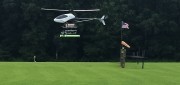
UAS for Agriculture, Ready for Take-off
February 26, 2014
Unmanned aerial systems (UAS) have recently become ubiquitous in the mass media and in trade publications, due to a variety...
February 26, 2014
Unmanned aerial systems (UAS) have recently become ubiquitous in the mass media and in trade publications, due to a variety...

Advocating for Geography Education: Interview with Kirk Goldsberry
December 17, 2013
A recent opinion piece by Kirk Goldsberry, visiting scholar at Harvard University, gained a good deal of attention because...
December 17, 2013
A recent opinion piece by Kirk Goldsberry, visiting scholar at Harvard University, gained a good deal of attention because...

Can Satellites in the Sky Help Prevent Atrocities on Earth?
November 25, 2013
Currently, about a dozen government and commercial Earth-imaging satellites circle the Earth daily. They take thousands of pictures...
November 25, 2013
Currently, about a dozen government and commercial Earth-imaging satellites circle the Earth daily. They take thousands of pictures...

SkyTruth Hopes to Make Skytruthing Into a Verb
October 15, 2013
SkyTruth has a mission to use remote sensing and digital mapping to educate the public and policymakers about the environmental...
October 15, 2013
SkyTruth has a mission to use remote sensing and digital mapping to educate the public and policymakers about the environmental...
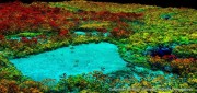
The Abyss, Now Live on Your Desktop
August 5, 2013
The advent of Earth-observation satellites transformed how we view our planet—from occasional snapshots to near continuous,...
August 5, 2013
The advent of Earth-observation satellites transformed how we view our planet—from occasional snapshots to near continuous,...
Applying Spatial and Temporal Intelligence to Marine Spatial Planning
August 5, 2013
There's an ongoing need to apply spatial and temporal intelligence to make sense of change. The Pacific Marine Analysis and Research...
August 5, 2013
There's an ongoing need to apply spatial and temporal intelligence to make sense of change. The Pacific Marine Analysis and Research...