Sensors

Receiver innovators log trends and product launches — Part 2
October 1, 2020
In the second part of our receiver feature, top receiver manufacturers discuss what’s on the horizon for GNSS receivers:...
October 1, 2020
In the second part of our receiver feature, top receiver manufacturers discuss what’s on the horizon for GNSS receivers:...

Soft information for IoT positioning
October 1, 2020
The billions of interconnected devices and sensors embedded in other devices, vehicles and even humans that collectively...
October 1, 2020
The billions of interconnected devices and sensors embedded in other devices, vehicles and even humans that collectively...
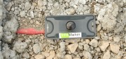
RFID Crazy: RFID-enabled infrastructure marking could become a cornerstone for a connected infrastructure management world.
March 19, 2019
Imagine if all public works engineers and utility company crew chiefs were equipped with a mobile device that could easily...
March 19, 2019
Imagine if all public works engineers and utility company crew chiefs were equipped with a mobile device that could easily...
FINAL ARTICLE IN THE SERIES on Geospatial Processing & Visualization: Ubisense and Harris Geospatial Solutions
August 4, 2017
The line between vendors of geospatial software and providers of geospatial data is increasingly blurred, as more companies...
August 4, 2017
The line between vendors of geospatial software and providers of geospatial data is increasingly blurred, as more companies...

Project Management, Collaboration, the Cloud, and Robots!
April 12, 2017
Trimble launches a new solution for construction project management– and takes a futuristic leap into autonomous construction...
April 12, 2017
Trimble launches a new solution for construction project management– and takes a futuristic leap into autonomous construction...

LIDAR Is Key To Autonomous Vehicles
February 23, 2017
Technology for autonomous vehicles builds on car navigation systems that have been commonplace for years and new collision-avoidance...
February 23, 2017
Technology for autonomous vehicles builds on car navigation systems that have been commonplace for years and new collision-avoidance...

Mapping the Scottish Seabed
February 21, 2017
On land, surveyors face challenges due to rough terrain, human activity, weather, and more. Usually, however, the ground...
February 21, 2017
On land, surveyors face challenges due to rough terrain, human activity, weather, and more. Usually, however, the ground...

Robots of the Deep
October 10, 2016
We have mapped the surface of the Moon at a resolution of 328 feet. We have mapped the surface of Mars. Yet, here on Earth,...
October 10, 2016
We have mapped the surface of the Moon at a resolution of 328 feet. We have mapped the surface of Mars. Yet, here on Earth,...
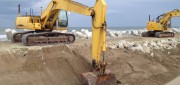
Moving Dirt Just Right
August 30, 2016
GNSS receivers help steer earth movers, providing users with accurate positions and no complexities. NavCom–a wholly owned...
August 30, 2016
GNSS receivers help steer earth movers, providing users with accurate positions and no complexities. NavCom–a wholly owned...

Wetlands Worth their Weight
March 2, 2016
"Wetland" is a generic term covering a wide variety of habitats that are wet for at least some period of time each year,...
March 2, 2016
"Wetland" is a generic term covering a wide variety of habitats that are wet for at least some period of time each year,...