Environment
Satellite Missions Improve Water Estimates
April 28, 2017
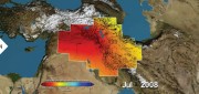
Fresh water is humanity’s single most critical resource. According to a recent United Nations report, stresses on water...
April 28, 2017
Fresh water is humanity’s single most critical resource. According to a recent United Nations report, stresses on water...

Mapping the Appalachian Trail (Part 2 of 2)
February 21, 2017
In 1998, the Appalachian Trail Conservancy (ATC) began its GIS program. Its first two challenges were to map the trail’s...
February 21, 2017
In 1998, the Appalachian Trail Conservancy (ATC) began its GIS program. Its first two challenges were to map the trail’s...
CLIVE: Communicating Risk in 3D
February 21, 2017
Static 3D models of topography and buildings are commonplace in both technical and popular geospatial software. There are still...
February 21, 2017
Static 3D models of topography and buildings are commonplace in both technical and popular geospatial software. There are still...

Robots of the Deep
October 10, 2016
We have mapped the surface of the Moon at a resolution of 328 feet. We have mapped the surface of Mars. Yet, here on Earth,...
October 10, 2016
We have mapped the surface of the Moon at a resolution of 328 feet. We have mapped the surface of Mars. Yet, here on Earth,...
LiDAR, GIS and the Chesapeake Conservancy: Precision Conservation
June 2, 2016
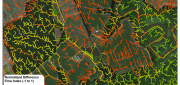
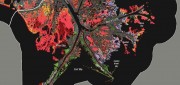
Building on the practice of precision agriculture and exploiting recent computer advances, the Chesapeake Conservancy (CC)...
June 2, 2016
Building on the practice of precision agriculture and exploiting recent computer advances, the Chesapeake Conservancy (CC)...
Wetlands Worth their Weight
March 2, 2016
"Wetland" is a generic term covering a wide variety of habitats that are wet for at least some period of time each year,...
March 2, 2016
"Wetland" is a generic term covering a wide variety of habitats that are wet for at least some period of time each year,...
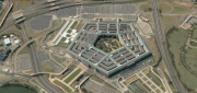
The Demise of Google Earth Enterprise: VRICON AND ARCGIS EARTH FILL THE GAP
December 28, 2015
Google is ending a 10-year run of Google Earth Enterprise (GEE), which contributed greatly to the market for geospatial “Digital...
December 28, 2015
Google is ending a 10-year run of Google Earth Enterprise (GEE), which contributed greatly to the market for geospatial “Digital...
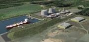
Oregon Preparing for Export: Assessing the Seismic Challenges of a Liquified Natural Gas Plant
December 3, 2015
In the international port of Coos Bay, Ore., construction will begin in late 2016 on a liquefied natural gas (LNG) export...
December 3, 2015
In the international port of Coos Bay, Ore., construction will begin in late 2016 on a liquefied natural gas (LNG) export...
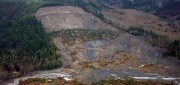
See the Light: LiDAR Data Help Expose Landslide Hazards
October 12, 2015
On March 22, 2014, four miles east of Oso, Wash., a portion of an unstable hill collapsed, sending mud and debris across...
October 12, 2015
On March 22, 2014, four miles east of Oso, Wash., a portion of an unstable hill collapsed, sending mud and debris across...
The Urgency of Building Bridges Between EO & Satcom
August 12, 2015
Currently, billions of individuals in every major world region— and billions of dollars worth of commerce—are supported...
August 12, 2015
Currently, billions of individuals in every major world region— and billions of dollars worth of commerce—are supported...