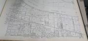
Cadaster
Recording, Registration, and Cadastres
September 18, 2017
An accurate and up-to-date record of property boundaries is essential for administering property taxes, enforcing environmental...
September 18, 2017
An accurate and up-to-date record of property boundaries is essential for administering property taxes, enforcing environmental...

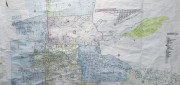
Cadasta: Mapping Land Rights from the Bottom Up
April 12, 2017
Cadasta helps put people on the map with a cloud-based platform for land-ownership data. In advanced industrial countries...
April 12, 2017
Cadasta helps put people on the map with a cloud-based platform for land-ownership data. In advanced industrial countries...
Geospatial PPPs
February 21, 2017
Land ownership is a foundation of national economies: those who have land titles can use them to obtain credit (which is often...
February 21, 2017
Land ownership is a foundation of national economies: those who have land titles can use them to obtain credit (which is often...
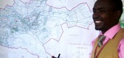
New GIS Promises to Revolutionize Tax Collection in Kenya
October 24, 2012
IN DEVELOPED COUNTRIES, MOST PEOPLE TAKE FOR GRANTED CERTAIN basic public goods, such as clean drinking water, public education...
October 24, 2012
IN DEVELOPED COUNTRIES, MOST PEOPLE TAKE FOR GRANTED CERTAIN basic public goods, such as clean drinking water, public education...
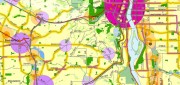
Portland, Oregon, Trailblazes a Successful Regional GIS
January 1, 2010
People from around the world come to Portland, Oregon, to study the city's successful model for growth management and comprehensive...
January 1, 2010
People from around the world come to Portland, Oregon, to study the city's successful model for growth management and comprehensive...