Aerial photography
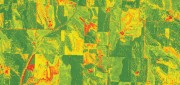
Aerial Self-sufficiency
March 5, 2019
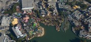
A large risk-assessment and data-analytics company created its own internal system to collect imagery, write software, and develop...
March 5, 2019
A large risk-assessment and data-analytics company created its own internal system to collect imagery, write software, and develop...
Predicting Crumbling Cliffs
March 5, 2019
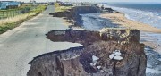
Cliff Erosion: a Global Issue In 2012, nine homes in Happisburgh, an historic village on England’s Norfolk coast,...
March 5, 2019
Cliff Erosion: a Global Issue In 2012, nine homes in Happisburgh, an historic village on England’s Norfolk coast,...
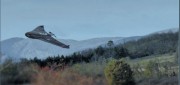
Standalone UAV Lidar
March 5, 2019
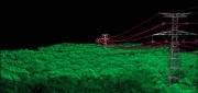
A surveying company developed a self-contained UAV lidar system so teams could gather data without a lidar specialist. Some...
March 5, 2019
A surveying company developed a self-contained UAV lidar system so teams could gather data without a lidar specialist. Some...
FINAL ARTICLE IN THE SERIES on Geospatial Processing & Visualization: Ubisense and Harris Geospatial Solutions
August 4, 2017
The line between vendors of geospatial software and providers of geospatial data is increasingly blurred, as more companies...
August 4, 2017
The line between vendors of geospatial software and providers of geospatial data is increasingly blurred, as more companies...
Imagery Companies Become Information Companies
April 12, 2017
New analytics and the cloud benefit customers using the ultimate big data: imagery In the past few years, the number of space-based...
April 12, 2017
New analytics and the cloud benefit customers using the ultimate big data: imagery In the past few years, the number of space-based...
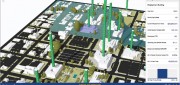
A State Gets Smart: SmarterBetterCities
February 21, 2017
To help formulate a 10-year strategic capital investment plan for the State of Oregon, the state’s Chief Financial Office...
February 21, 2017
To help formulate a 10-year strategic capital investment plan for the State of Oregon, the state’s Chief Financial Office...
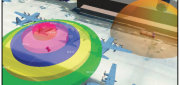
CLIVE: Communicating Risk in 3D
February 21, 2017
Static 3D models of topography and buildings are commonplace in both technical and popular geospatial software. There are still...
February 21, 2017
Static 3D models of topography and buildings are commonplace in both technical and popular geospatial software. There are still...
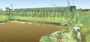
Capturing the Bluestone Dam
February 21, 2017
The Bluestone Damon the New River in West Virginia was completed in 1952. It’s 165 feet high above the stream bed and about...
February 21, 2017
The Bluestone Damon the New River in West Virginia was completed in 1952. It’s 165 feet high above the stream bed and about...
Surveying a Mountain Highway with UAS
February 21, 2017
In the steep canyons of the Republic of Macedonia, AKTOR ADT, an international construction company based in Athens, Greece,...
February 21, 2017
In the steep canyons of the Republic of Macedonia, AKTOR ADT, an international construction company based in Athens, Greece,...
Automating the Mundane
January 19, 2017
You don’t have to work for huge organizations, such as the U.S. Air Force or the U.S. Forest Service, to appreciate the benefits...
January 19, 2017
You don’t have to work for huge organizations, such as the U.S. Air Force or the U.S. Forest Service, to appreciate the benefits...