UAS

Shining Light on the Past
October 1, 2020
The collection of about 300 giant geoglyphs known as Nasca Lines were etched into the ground in the Peruvian coastal plain...
October 1, 2020
The collection of about 300 giant geoglyphs known as Nasca Lines were etched into the ground in the Peruvian coastal plain...
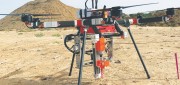
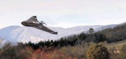
UAV Stakes Out New Ground
September 27, 2019
A flying/staking robot has taken a huge step forward in automation for site layout, including road, rail, utilities, and energy...
September 27, 2019
A flying/staking robot has taken a huge step forward in automation for site layout, including road, rail, utilities, and energy...
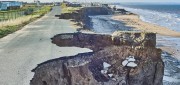
Predicting Crumbling Cliffs
March 5, 2019
Cliff Erosion: a Global Issue In 2012, nine homes in Happisburgh, an historic village on England’s Norfolk coast,...
March 5, 2019
Cliff Erosion: a Global Issue In 2012, nine homes in Happisburgh, an historic village on England’s Norfolk coast,...
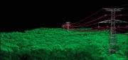
Standalone UAV Lidar
March 5, 2019
A surveying company developed a self-contained UAV lidar system so teams could gather data without a lidar specialist. Some...
March 5, 2019
A surveying company developed a self-contained UAV lidar system so teams could gather data without a lidar specialist. Some...
Surveying a Mountain Highway with UAS
February 21, 2017
In the steep canyons of the Republic of Macedonia, AKTOR ADT, an international construction company based in Athens, Greece,...
February 21, 2017
In the steep canyons of the Republic of Macedonia, AKTOR ADT, an international construction company based in Athens, Greece,...
Trimble UAS Answers Tall Task
November 9, 2015
In the steep canyons of the Republic of Macedonia — a landlocked Balkan nation of mountains, lakes and ancient towns — international...
November 9, 2015
In the steep canyons of the Republic of Macedonia — a landlocked Balkan nation of mountains, lakes and ancient towns — international...

Moving Forward with UAS Mapping
June 16, 2015
For geospatial professionals, the most exciting aspect of the current explosion in unmanned aircraft systems (UASs) is using...
June 16, 2015
For geospatial professionals, the most exciting aspect of the current explosion in unmanned aircraft systems (UASs) is using...
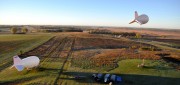
Tethered Aerostats Provide Another Option in the Sky
October 31, 2014
Geospatial professionals are able to choose from an increasingly wide array of platforms on which to deploy ever more accurate...
October 31, 2014
Geospatial professionals are able to choose from an increasingly wide array of platforms on which to deploy ever more accurate...
From Traditional Photogrammetry to UAS
October 15, 2014
Photogrammetry has changed substantially in the past three decades. When Jeff Yates began in the business 32 years ago,...
October 15, 2014
Photogrammetry has changed substantially in the past three decades. When Jeff Yates began in the business 32 years ago,...
UAS for Agriculture, Ready for Take-off
February 26, 2014
Unmanned aerial systems (UAS) have recently become ubiquitous in the mass media and in trade publications, due to a variety...
February 26, 2014
Unmanned aerial systems (UAS) have recently become ubiquitous in the mass media and in trade publications, due to a variety...