Other

Integrating photonic chips for better performance
October 12, 2020
In June, KVH Industries launched the P-1775 inertial measurement unit (IMU), featuring its new PIC Inside photonic integrated...
October 12, 2020
In June, KVH Industries launched the P-1775 inertial measurement unit (IMU), featuring its new PIC Inside photonic integrated...
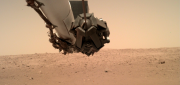
NASA’s Eyes on Mars
September 27, 2019
An old imaging technology is outdated for use on Earth, but it’s the perfect fit for today’s remote-sensing needs on Mars. Since...
September 27, 2019
An old imaging technology is outdated for use on Earth, but it’s the perfect fit for today’s remote-sensing needs on Mars. Since...

Moving Dirt Just Right
August 30, 2016
GNSS receivers help steer earth movers, providing users with accurate positions and no complexities. NavCom–a wholly owned...
August 30, 2016
GNSS receivers help steer earth movers, providing users with accurate positions and no complexities. NavCom–a wholly owned...

Space Engineer In Training
June 2, 2016
Last summer, NASA dropped three small airplanes from 100 feet in tests meant to simulate severe but survivable crashes. It collected...
June 2, 2016
Last summer, NASA dropped three small airplanes from 100 feet in tests meant to simulate severe but survivable crashes. It collected...

Blending Realities
November 11, 2015
Imagine designing an object, in 3D and color, using only gaze, gestures, and voice (GGV) commands. Imagine designing an entire...
November 11, 2015
Imagine designing an object, in 3D and color, using only gaze, gestures, and voice (GGV) commands. Imagine designing an entire...

Tracking Aircraft in Flight
April 10, 2015
The disappearance of Malaysia Airlines Flight 370 on March 8, 2014, with 239 people on board, was both tragic and stunning....
April 10, 2015
The disappearance of Malaysia Airlines Flight 370 on March 8, 2014, with 239 people on board, was both tragic and stunning....
Sensor Fusion: Deriving Information from Data
April 9, 2015
The current explosion in the variety, capability and sheer number of sensors is generating a flood of data intended to enhance...
April 9, 2015
The current explosion in the variety, capability and sheer number of sensors is generating a flood of data intended to enhance...
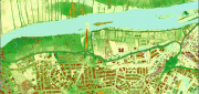
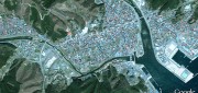
Mapping People: Human Landscape
August 12, 2014
The executive director of an international nonprofit organization needs to map all the hospitals, clinics, and first aid facilities...
August 12, 2014
The executive director of an international nonprofit organization needs to map all the hospitals, clinics, and first aid facilities...

exactEarth Provides Unique Insight Into Global Ocean Traffic
March 11, 2013
exactEarth has successfully launched an earth observation satellite constellation to track Automated Identification System...
March 11, 2013
exactEarth has successfully launched an earth observation satellite constellation to track Automated Identification System...
Google Earth Builder: Productizing Server Farms for Storing and Processing Geospatial Data
March 24, 2012
Google Earth Builder (GEB), which Google released last fall, enables private companies and government agencies to store and process...
March 24, 2012
Google Earth Builder (GEB), which Google released last fall, enables private companies and government agencies to store and process...