Maximizing the Sun: Solar energy grows in part due to aerial imaging and surveying
Solar power is booming in the United States. “Every three weeks,” President Obama said in his 2015 State of the Union address, “we bring online as much solar power as we did in all of 2008.” Geospatial technologies—especially remote sensing and surveying—play an important role in siting, designing, and constructing solar arrays, from a few panels on the roof of a house to hundreds of thousands of panels in huge solar farms.
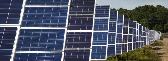
The biggest challenge to maximizing the power output of solar panels is … shade! Passing clouds, topographic features, trees, buildings, rooftop installations such as HVAC systems, and even adjacent panels can block the sun’s rays from reaching solar panels. Smart design and construction can mitigate shading, but site selection based on high-resolution aerial imaging and surveying can minimize it up front.
Currently, a popular solar energy project type is utility ground-mounted solar arrays. “Agricultural fields or different parcels of land get acquired for the purpose of designing and installing solar systems, typically by developers who have projects and have obtained power-purchase agreements with utilities,” says Sam Laughlin, who runs the civil engineering department at Blue Oak Energy, a company that designs commercial and utility solar photovoltaic (PV) projects for rooftops, carports, and open real estate across the United States and abroad. “They will ask us to engineer the system for them and put together the construction documents.”