Remote sensing

Walter Scott: Analytics and Monitoring Drive DigitalGlobe Growth
November 19, 2012
DigitalGlobe has had amazing stock performance of greater than 22 percent growth over the past five years and nearly 30 percent...
November 19, 2012
DigitalGlobe has had amazing stock performance of greater than 22 percent growth over the past five years and nearly 30 percent...

Mark Romano: Earth Eye Makes Inroads in Sensor Fusion
November 5, 2012
Earth Eye is a relatively new company that has been focused on LiDAR data capture, and the fusion of LiDAR with other sensor...
November 5, 2012
Earth Eye is a relatively new company that has been focused on LiDAR data capture, and the fusion of LiDAR with other sensor...

Shoshanna Budzianowski: Eye on Earth: Microsoft Continues Investment in Network
August 21, 2012
THE EYE ON EARTH (EOE) NETWORK has garnered a great deal of praise for providing European environmental data openly and transparently,...
August 21, 2012
THE EYE ON EARTH (EOE) NETWORK has garnered a great deal of praise for providing European environmental data openly and transparently,...

Wade Larson and George Tyc: UrtheCast Promises a Live Video Feed of Earth from Space
June 12, 2012
UrtheCast is a company created to provide the first live high-definition video feed of Earth from space. Working jointly...
June 12, 2012
UrtheCast is a company created to provide the first live high-definition video feed of Earth from space. Working jointly...

Business Uses of Satellite Imagery
June 1, 2012
The public is familiar with satellite imagery through consumer applications — most notably, Google Earth. GeoEye (Herndon,...
June 1, 2012
The public is familiar with satellite imagery through consumer applications — most notably, Google Earth. GeoEye (Herndon,...
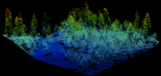
Mapping Carbon in the Forests: Seeing Both the Forest and the Trees
May 8, 2012
Carbon dioxide (CO2) is the most important anthropogenic greenhouse gas. As forests grow, they absorb CO2 from the atmosphere,...
May 8, 2012
Carbon dioxide (CO2) is the most important anthropogenic greenhouse gas. As forests grow, they absorb CO2 from the atmosphere,...
LiDAR Software Update: Companies Respond to Customer Demands
February 25, 2012
The market for software to manage, process, fuse, and visualize LiDAR point cloud data is still very young and amorphous....
February 25, 2012
The market for software to manage, process, fuse, and visualize LiDAR point cloud data is still very young and amorphous....
Radar Update: Applications Abound in Defense, Maritime and Engineering
October 25, 2011
Whether used to view Earth’s surface through clouds or at night, to measure the thickness of polar ice sheets, to map long-abandoned...
October 25, 2011
Whether used to view Earth’s surface through clouds or at night, to measure the thickness of polar ice sheets, to map long-abandoned...
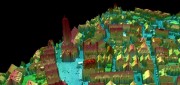
Processing Point Clouds: 3D Data Update
October 25, 2011
Like raster and vector data many years ago, 3D clouds of billions of LiDAR points — which can be colored and very realistic...
October 25, 2011
Like raster and vector data many years ago, 3D clouds of billions of LiDAR points — which can be colored and very realistic...
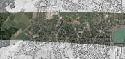
Global Ortho Project: Continuous, Consistent and Current Coverage
July 1, 2011
Microsoft’s Global Ortho (GO) project aims to capture the entire continental United States and Western Europe at a spatial...
July 1, 2011
Microsoft’s Global Ortho (GO) project aims to capture the entire continental United States and Western Europe at a spatial...