Item type

Geodetic Control over Time and Space in California
August 4, 2017
Interview with Scott Martin, Chief of Geodetic Control and GNSS Surveys, California DoT Matteo Luccio: Scott, what is your...
August 4, 2017
Interview with Scott Martin, Chief of Geodetic Control and GNSS Surveys, California DoT Matteo Luccio: Scott, what is your...

FINAL ARTICLE IN THE SERIES on Geospatial Processing & Visualization: Ubisense and Harris Geospatial Solutions
August 4, 2017
The line between vendors of geospatial software and providers of geospatial data is increasingly blurred, as more companies...
August 4, 2017
The line between vendors of geospatial software and providers of geospatial data is increasingly blurred, as more companies...

Shifting Ground: USGS on Earth Movement after an Earthquake
June 29, 2017
Ken Hudnut, science advisor for risk reduction, US Geological Survey, talks GPS and earthquakes Editor’s note: In many...
June 29, 2017
Ken Hudnut, science advisor for risk reduction, US Geological Survey, talks GPS and earthquakes Editor’s note: In many...
The iCon build: Adding Adaptable Options for Layout Automation
June 29, 2017
At CONEXPO 2017, we were given a demonstration of one tool in the new wave of automated layout solutions for vertical...
June 29, 2017
At CONEXPO 2017, we were given a demonstration of one tool in the new wave of automated layout solutions for vertical...
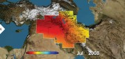
Satellite Missions Improve Water Estimates
April 28, 2017
Fresh water is humanity’s single most critical resource. According to a recent United Nations report, stresses on water...
April 28, 2017
Fresh water is humanity’s single most critical resource. According to a recent United Nations report, stresses on water...

Neutrino Beam! Scanning a Ring Tunnel
April 17, 2017
The surveying challenges for construction related to a particle accelerator are exacting—but surprisingly familiar. Trillions...
April 17, 2017
The surveying challenges for construction related to a particle accelerator are exacting—but surprisingly familiar. Trillions...
Imagery Companies Become Information Companies
April 12, 2017
New analytics and the cloud benefit customers using the ultimate big data: imagery In the past few years, the number of space-based...
April 12, 2017
New analytics and the cloud benefit customers using the ultimate big data: imagery In the past few years, the number of space-based...

Cadasta: Mapping Land Rights from the Bottom Up
April 12, 2017
Cadasta helps put people on the map with a cloud-based platform for land-ownership data. In advanced industrial countries...
April 12, 2017
Cadasta helps put people on the map with a cloud-based platform for land-ownership data. In advanced industrial countries...

Project Management, Collaboration, the Cloud, and Robots!
April 12, 2017
Trimble launches a new solution for construction project management– and takes a futuristic leap into autonomous construction...
April 12, 2017
Trimble launches a new solution for construction project management– and takes a futuristic leap into autonomous construction...

GNSS Mission: Accomplished
April 12, 2017
Editor’s note: So rarely do new major players arise in the high-precision GNSS industry that we feel the following to be a significant...
April 12, 2017
Editor’s note: So rarely do new major players arise in the high-precision GNSS industry that we feel the following to be a significant...