xyHt

Freeing the Data
November 6, 2018
A Canadian software company is making it easy for the geospatial community (and beyond) to work with, exchange, and extract...
November 6, 2018
A Canadian software company is making it easy for the geospatial community (and beyond) to work with, exchange, and extract...

Radiant.Earth
November 6, 2018
Nonprofits working on global development issues have had great difficulty acquiring and using a staple source of geospatial...
November 6, 2018
Nonprofits working on global development issues have had great difficulty acquiring and using a staple source of geospatial...

Easing the 3D Workflow
February 19, 2018
For 30 years, an Alaska-based company has been producing digital mapping and photogrammetic software to help automate the complex...
February 19, 2018
For 30 years, an Alaska-based company has been producing digital mapping and photogrammetic software to help automate the complex...
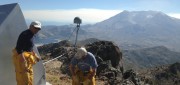
Shifting Ground: GNSS for Earthquakes
February 19, 2018
This is the third article in a series in xyHt introducing readers to scientists and technologists who work in pursuit of early-warning...
February 19, 2018
This is the third article in a series in xyHt introducing readers to scientists and technologists who work in pursuit of early-warning...

Managing Canada’s Data
February 7, 2018
From mapping utility poles to mapping radio frequency signal leaks, this company collects and manages much of the country’s...
February 7, 2018
From mapping utility poles to mapping radio frequency signal leaks, this company collects and manages much of the country’s...
Recording, Registration, and Cadastres
September 18, 2017
An accurate and up-to-date record of property boundaries is essential for administering property taxes, enforcing environmental...
September 18, 2017
An accurate and up-to-date record of property boundaries is essential for administering property taxes, enforcing environmental...

Geodetic Control over Time and Space in California
August 4, 2017
Interview with Scott Martin, Chief of Geodetic Control and GNSS Surveys, California DoT Matteo Luccio: Scott, what is your...
August 4, 2017
Interview with Scott Martin, Chief of Geodetic Control and GNSS Surveys, California DoT Matteo Luccio: Scott, what is your...
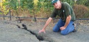
Shifting Ground: USGS on Earth Movement after an Earthquake
June 29, 2017
Ken Hudnut, science advisor for risk reduction, US Geological Survey, talks GPS and earthquakes Editor’s note: In many...
June 29, 2017
Ken Hudnut, science advisor for risk reduction, US Geological Survey, talks GPS and earthquakes Editor’s note: In many...
The iCon build: Adding Adaptable Options for Layout Automation
June 29, 2017
At CONEXPO 2017, we were given a demonstration of one tool in the new wave of automated layout solutions for vertical...
June 29, 2017
At CONEXPO 2017, we were given a demonstration of one tool in the new wave of automated layout solutions for vertical...

Neutrino Beam! Scanning a Ring Tunnel
April 17, 2017
The surveying challenges for construction related to a particle accelerator are exacting—but surprisingly familiar. Trillions...
April 17, 2017
The surveying challenges for construction related to a particle accelerator are exacting—but surprisingly familiar. Trillions...