Surveying
Mapping the Appalachian Trail (Part 1 of 2)
May 26, 2015
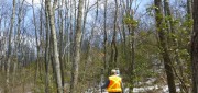
How the AT was created and surveyed, from Avery’s wheel to GPS The Appalachian Trail (AT) is very old, very long, and iconic....
May 26, 2015
How the AT was created and surveyed, from Avery’s wheel to GPS The Appalachian Trail (AT) is very old, very long, and iconic....

Maximizing the Sun: Solar energy grows in part due to aerial imaging and surveying
April 10, 2015
Solar power is booming in the United States. “Every three weeks,” President Obama said in his 2015 State of the Union...
April 10, 2015
Solar power is booming in the United States. “Every three weeks,” President Obama said in his 2015 State of the Union...

Completing the Lake Wobegon Trail: Vision to Design
April 9, 2015
The urban areas in Stearns County, Minnesota, are like islands in a sea of corn, soybean and dairy farms. Through this bucolic...
April 9, 2015
The urban areas in Stearns County, Minnesota, are like islands in a sea of corn, soybean and dairy farms. Through this bucolic...

Real-Time Monitoring A Hit Down Under
January 11, 2015
In the heart of Brisbane, Australia’s third most populous city, constructioncompany Watpac Australia Pty. Ltd. has a contract...
January 11, 2015
In the heart of Brisbane, Australia’s third most populous city, constructioncompany Watpac Australia Pty. Ltd. has a contract...
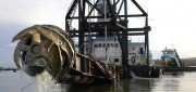
Survey. Dredge. Repeat. Keeping the Columbia River Navigable
December 29, 2014
As the skipper of Galileo 3, a 30-foot sailboat on the Columbia River, I tell my crew that I am comfortable with 15 feet...
December 29, 2014
As the skipper of Galileo 3, a 30-foot sailboat on the Columbia River, I tell my crew that I am comfortable with 15 feet...
From Shore to Floor
October 16, 2014
More than 90% of the world’s trade is carried by sea, according to the International Maritime Organization. Therefore,...
October 16, 2014
More than 90% of the world’s trade is carried by sea, according to the International Maritime Organization. Therefore,...
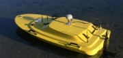
Hydrography by Remote
May 6, 2014
Before they even start taking measurements, surveyors often have to deal with such practical challenges as how to access...
May 6, 2014
Before they even start taking measurements, surveyors often have to deal with such practical challenges as how to access...
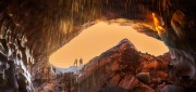
Under Thin Ice: Mapping changing glaciers from the inside
February 27, 2014
Mountaineers climb mountains. Cavers explore caves. Surveyors measure and map. In Oregon, a small team of people with all three...
February 27, 2014
Mountaineers climb mountains. Cavers explore caves. Surveyors measure and map. In Oregon, a small team of people with all three...